Designing an AI-Powered Maritime Intelligence Platform

An AI-powered maritime surveillance system designed to monitor, analyze, and secure national waters in real time. By integrating satellite data, vessel detection technologies, and intelligent processing, Helix enables naval operators to identify unprotected maritime zones, detect unauthorized vessel activity, and respond proactively to potential threats.
TASK
Design an AI-powered maritime surveillance system that enables naval operators to monitor vessel activity, identify unprotected maritime zones, and respond to potential threats in real time through an integrated command interface.
ROLE
User Research
System & UX Strategy
UX Design
UI Design
TEAM DISTRIBUTON
1 Product Designer (UI/UX)
PROJECT INCLUDES
UI/UX Design
Final Design
Prototype
COMPANY
Pensieve Digital Indonesia for Anonymous Government institution
YEAR
2025-2026
This case study has been adapted in compliance with a non-disclosure agreement. Certain elements such as brand names, product names, visual styles, and key features have been modified. However, the core use cases and user needs remain representative of the original work.

BACKGROUND
In recent years, several cross-border conflicts have occurred across Southeast Asia, highlighting growing concerns over maritime security. One of the recurring issues is the presence of illegal foreign vessels entering Indonesian waters and remaining undetected for extended periods. This problem is primarily caused by two factors: limited naval coverage in certain maritime areas and the absence of advanced monitoring systems capable of detecting and tracking unauthorized vessels in real time. To address these challenges, there is a need for an integrated system powered by artificial intelligence that can enhance surveillance, improve response time, and strengthen overall maritime defense.

These images are sourced from various national news outlets documenting illegal foreign vessels entering Indonesian waters without authorization. The vessels are reported to be involved in illegal fishing and other suspicious activities, as identified through reports from local Indonesian fishermen.
END-TO-END MARITIME DETECTION SYSTEM
This section outlines how Helix integrates satellite monitoring, vessel detection, data transmission, and AI processing into a unified system. The architecture is designed to support real-time analysis and enable efficient decision-making within complex maritime environments.

IDEA GENERATION
Through collaboration with maritime experts and stakeholders, we identified four critical user needs that serve as the foundation for the product. These insights guided feature development and design decisions, ensuring the solution addresses operational challenges and aligns with current technological capabilities.

FROM INSIGHTS TO DESIGN DIRECTION
Based on key insights derived from research and cross-functional collaboration, I identified the critical challenges that needed to be addressed. These insights were translated into user stories and How Might We statements, which guided the design exploration and informed the overall direction of the system.
UNDERSTAND THE USER'S NEEDS
🙋🏼♀️
As a naval operator, I want unauthorized vessels and unprotected maritime zones highlighted on the map so that I can quickly identify threats and take appropriate action.
🙋🏿♂️
As a naval operator, I want to receive real-time alerts when unauthorized or unidentified vessels enter Indonesian waters so that I can initiate immediate response and interception procedures.
🙋🏻
As a naval operator, I want to identify maritime zones with limited or no active surveillance so that I can strategically deploy naval units and defense systems to high-risk areas.
THE CHALLENGE
👷🏿♂️
How might we help naval operators quickly identify unauthorized vessels and vulnerable maritime zones to enable faster threat response?
👷🏻♀️
How might we enable naval operators to detect and respond to unauthorized vessels in real time so they can prevent prolonged illegal presence in Indonesian waters?
👷🏾
How might we help naval operators quickly identify and prioritize unprotected maritime zones so they can deploy resources more strategically and efficiently?
DESIGN STRATEGIES
Real-Time Situational Awareness
Visualize vessels, patrol zones, and blind spots in a unified real-time map.
Smart Alert Prioritization
Surface high-risk threats through AI-driven alerts and clear visual hierarchy.
Action-Oriented Workflows
Enable rapid response with contextual actions and streamlined operational flows.
Scalable Coverage Insight
Support seamless navigation from national surveillance to vessel-level intelligence.
INFORMATION ARCHTECHTURE
Following alignment with product requirements and key system functionalities, I structured the information architecture to support clear navigation and efficient access to critical data. Given the complexity of maritime monitoring, the architecture prioritizes quick access to alerts, coverage insights, and vessel tracking.
The flow presented here is a simplified version for portfolio purposes; the actual system includes more detailed and layered structures.

USER FLOW
I designed user flows to map how naval operators interact with the system—from detecting anomalies to initiating response actions. These flows ensure that critical tasks can be completed quickly, with minimal friction, especially in time-sensitive scenarios.

INITIAL INTERFACE
The user flows were translated into low-fidelity wireframes to explore layout, interaction patterns, and data hierarchy. These initial designs focus on clarity, information prioritization, and usability, serving as the foundation for developing high-fidelity interfaces.


VISUAL DESIGN LANGUAGE
A cohesive visual system designed to support mission-critical operations through structured layouts, consistent iconography, technical typography, and a semantic color system. Every visual element was intentionally crafted to improve readability, reduce cognitive load, and accelerate decision-making in high-density operational environments.
Modular Dashboard Architecture

The interface is built on a modular dashboard architecture that organizes complex information into clearly defined sections, allowing users to quickly distinguish between primary insights, supporting data, and actionable content. By combining consistent spacing, visual hierarchy, and progressive disclosure, the layout reduces cognitive load while enabling faster scanning and more confident decision-making in data-intensive environments.
Unified Iconography System

The iconography was designed as a unified visual system that combines geometric forms, consistent proportions, and recognizable metaphors to improve navigation and feature recognition. A structured three-state approach-outline, filled, and active-provides clear interaction feedback, while subtle gradients and depth reinforce the platform's military-tech aesthetic without sacrificing clarity or usability.
Technical Typography

Chakra Petch was chosen for its geometric structure and technical appearance, reinforcing the platform's military-tech identity while maintaining excellent readability across high-density operational data. Its structured letterforms and distinctive numerals improve the recognition of mission-critical information, while a clear typographic hierarchy guides users from primary system status to supporting operational details with minimal cognitive effort.
Functional Color System

The color system adopts a functional approach, where each color communicates operational meaning rather than decoration. A deep navy foundation minimizes eye fatigue and establishes a command-center environment, while cyan highlights surveillance and active system information, and magenta emphasizes primary actions and critical metrics. Neutral text tones create a clear reading hierarchy, ensuring users can quickly distinguish between primary information, supporting content, and interactive elements with minimal cognitive effort.
THE SOLUTION
The final design presents Helix as an integrated command interface that enables real-time maritime monitoring, intelligent threat detection, and strategic response planning. While this case study is presented in a structured, linear format, the actual design process involved multiple iterations, continuous validation, and close collaboration with product, engineering, and domain stakeholders to ensure the system meets real operational demands.
Solution 1: Highlighted Vessel and Zone
🙋🏼♀️
As a naval operator, I want unauthorized vessels and unprotected maritime zones highlighted on the map so that I can quickly identify threats and take appropriate action.
👷🏿♂️
How might we help naval operators quickly identify unauthorized vessels and vulnerable maritime zones to enable faster threat response?
✨
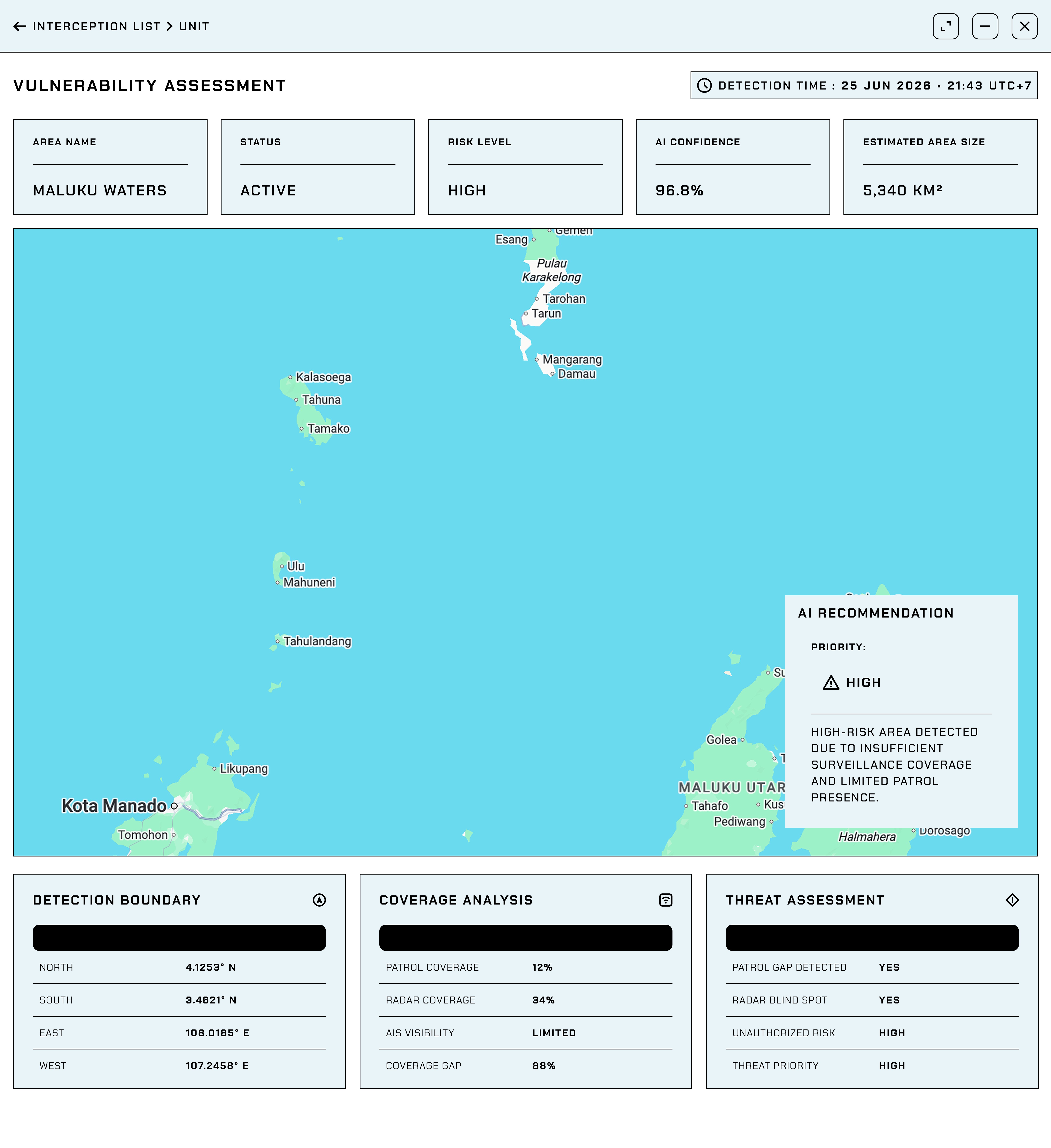
Implemented a map-based monitoring system that highlights unauthorized vessels and unprotected maritime zones with actionable insights, enabling faster threat identification and response.
Solution 2: Unidentified Vessels
🙋🏻
As a naval operator, I want to receive real-time alerts when unauthorized or unidentified vessels enter Indonesian waters so that I can initiate immediate response and interception procedures.
👷🏾
How might we enable naval operators to detect and respond to unauthorized vessels in real time so they can prevent prolonged illegal presence in Indonesian waters?
✨
Implemented real-time vessel intrusion alerts that notify operators of unauthorized and unidentified vessels, enabling immediate interception and response.
Solution 3: Unprotected Area
🙋🏿♂️
As a naval operator, I want to identify maritime zones with limited or no active surveillance so that I can strategically deploy naval units and defense systems to high-risk areas.
👷🏻♀️
How might we help naval operators quickly identify and prioritize unprotected maritime zones so they can deploy resources more strategically and efficiently?
✨
Implemented surveillance gap visualization to identify vulnerable maritime zones, supporting strategic resource allocation and deployment decisions.
LIVE PROTOTYPE
Please explore the live prototype to experience the finalized flow and design implemented in the final version.
Click “Expand Icon” to view it in full size for a better and more immersive experience.
LIMITATION & OBSTACLE
Limited Access to
Domain Experts
Restricted access to naval personnel and real-world operational workflows.
Data Availability & Accuracy Constraints
Incomplete or delayed maritime data affected detection accuracy.
Complexity of AI
Integration
Ensuring AI-generated insights remained transparent and actionable.
Operational & Environmental Constraints
System usability needed to perform in harsh maritime environments.
IMPACT
For the Client
Improved maritime visibility, enabling faster threat detection and operational decision-making.
For the Nation
Enhanced maritime security through earlier identification of unauthorized activities and coverage gaps.
For the Company
Strengthened positioning as a provider of AI-powered defense and surveillance solutions.
GET IN TOUCH

© FENDRA PUNU. SENIOR PRODUCT DESIGNER (UI/UX). AUGSBURG - GERMANY. 2026. ALL RIGHTS RESERVED.